
April 21 8:30 a.m.
MV reports that Wilno Road North below Heritage Park is closed due to a washout. Please avoid the area and use Municipal 511 for road closures and alternate routes.
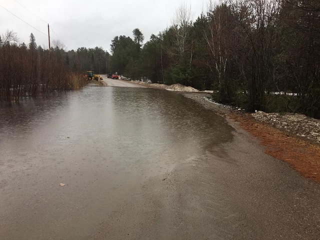
April 20 2:30 p.m.
Municipal511.ca lists additional problems below due to flooding. Click HERE to check latest updates in Eastern Ontario on municipal511.ca before you drive.
- Brudnell Lyndoch Raglan: John Watson Road 3229m South of Opeongo Road (major wash out, road closed, no emergency access);
- Killaloe Hagarty Richards: Scenic Road from 790m East of Rozek Road to Rozek Road (road closed); Heritage Road (closed from Old Trestle Road to civic #610 due to high flood waters); Heritage Road (closed from civic #1053 to Mask Road); Mask Road from 89m West of Hwy 60 to 33m East of Round Lake Road (short-term road closure due to high flood waters);
- Madawaska Valley: Paugh Lakd Road 44m South of Gunns Road (short-term road closure); Siberia Road from McMaster Lake Lane to Babinski Road (narrow road); Opeongo Road 1858m West of Wilno South Road (road washed out);
April 20 8:30 a.m.
Short term road closure at Finch Road 821m North of Palmer Road, due to culvert wash out.
April 19 7:30 p.m.
Madawaska Valley advises that currently Peplinski Homestead Road, Trebenski Road to Basin Depot is closed as well as Finch Road. Opeongo Road East is closed to local drive only. MVwill continue to update as information becomes available. Click HERE to check with municipal 511 for road closures.
April 19 7:25 p.m.
The Upper Ottawa Valley Detachment of the Ontario Provincial Police (OPP) advises motorists that a section of Round Lake Road, between Doran Road and Simpson Pit Road, has been closed due to localized flooding. The roadway will be closed until further notice. Municipal road crews have posted closure and detour signs.
Drivers across eastern Ontario are advised to be alert for potential flooding. If you come across a section of submerged roadway, turn around and find an alternate route. Water can hide dangers such as washed-out sections of roadway. Not only is it dangerous, it is also an offence to drive on a closed highway.
Monitor @OPPCommunicationsER and @511OntarioEastern on Twitter or 511on.ca for updated road conditions.
April 19 1:15 p.m.
A Red Rock Road resident in Killaloe Hagarty Richards Township has advised The Current that County of Renfrew personnel have unblocked a culvert at Jack’s Creek. Carol Clendenning said that there has been considerable erosion under half of a seasonal cottage near Round Lake as a result of water from the creek. She said County personnel said the property owners in the US have been informed.
April 19 12:00 p.m.
Madawaska Valley Township advises that MV Operations Department is out monitoring and fixing washouts that have resulted from the rain and spring thaw. Currently Peplinski Homestead Road is closed. Please drive carefully and be aware of the washouts.
April 18 12:00 p.m.
Ministry of Natural Resources and Forestry – Flood Watch – Pembroke District advised area residents that a Flood Watch is in effect in the District until Thursday, April 25, 2019.
Residents of Renfrew County should be advised that water levels are rising due to recent precipitation and will continue to rise as snow melts. For safety, all residents should keep a close watch on conditions, regularly check for updated messages and exercise caution near fast-moving rivers and streams. Residents who have a historic susceptibility to flooding should take appropriate precautions to protect their property, such as ensuring sump pumps are functioning and securing items that may float away as water levels rise.
The ministry is closely monitoring the weather and developing watershed conditions. Further updates will be issued as appropriate.
April 18: Potential for flooding
Madawaska Valley Township website published advice on April 18 that staff are aware and monitoring the potential of flooding over the next few days. With the additional significant rainfall (over 50mm) and warmer temperatures forecasted water levels may exceed minor flooding levels over the Easter weekend in flood prone areas. Preparations are being made at the municipal mevel in the event of flooding. The municipality said it will continue working with the Ministry of Natural Resources and Forestry as well as the Provincial Emergency Operations Centre to provide updates on its website and social media sites as they become available.
Editor’s Note: The Township has published on its website madawaskavalley.ca the following links to useful resources for residents, which we include below for readers’ convenience. Click on each (pdf) to access the document:
If you need to sand bag, save time and do it right. How to sand bag (pdf)
Flood information:
Disaster Recovery Assistance for Ontarians: Application Form (pdf)
Disaster Recovery Assistance for Ontarians: Program Guidelines (pdf)
Disaster Recovery Assistance Info Sheet (pdf)
Disaster Recovery Speical Provisions for Low Income Households (pdf)
Steps Well Owners Need to Take After a Flood (pdf)
Keeping Food Safe After a Flood (pdf)
Flood Safety for Propane Users (pdf)
Caring for Your Well During and After a Flood (pdf)
Red Cross Guide to Flood Recovery (pdf)
Red Cross Direct Financial Assistance (pdf)
Photo: Round Lake Property Owners Association